The sand was deposited there as outwash from retreating glaciers. The winds that followed (and continue today) blew the barren sand into huge dunes, some as high as 400 feet and as wide as 20 miles, so they appear as hills. If you view satellite imagery, however, it's very obvious they are sand dunes. Vegetation eventually began to grow and (mostly) cemented the dunes in place where they remain today.
The area is the largest sand dune formation in the western hemisphere covering about 20,000 square miles. The dunes also sit on the Ogalla Aquifer which contains 1 billion acre-feet of ground water. Because of this the otherwise very dry area contains numerous lakes when water levels are high. I have noticed some of these small lakes.
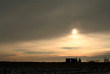
If not for the railroad, Highway 2, fence, and some scattered ranches the area looks much like it did after vegetation took over the dunes. The sand is terrible for farming but great for ranching. Numerous windmills use the power of wind, the very source of power that created the massive dunes, to bring Ogalla water to the surface. It's an interesting circle here in the Sand Hills.
1 comment:
nebraska is still lame on so many levels, though. i mean... seriously.
Post a Comment